Mount Hermon Villages and Working Sites
Mount Hermon Municipality Federation / Jabal El Sheikh Municipalities Federation
Mount Hermon, or Jabal El-Sheikh, is a snowcapped ridge on the Lebanon-Syria border west of Damascus. It rises to 9,232 feet (2,814 metres) and is the highest point on the east coast of the Mediterranean Sea. It is considered the southernmost extension of the Anti-Lebanon range. At its foot rise the two major sources of the Jordan River. Hermon has also been known historically as Sirion and Senir.
Mount Hermon geographical area comprises 31,645 Hectares of land, out of which 10,414.58 ha agricultural land. Jabal El Sheikh Municipalities Federation includes fourteen towns and villages in Rachaya district that are located at the feet of Hermon Mountain (Jabal El Sheikh). The union includes: Rachaya, Aen Ata, Aen Hirshy, Tannoura, Beit Lahya, Bakifa, Akaba, Houch, Kfar Mishky, Majdal Balhees, Kawkaba, Daher El Ahmar, Ayha, and Kfarkouk.
The technical reasons beyond choosing three sites within Mount Hermon KBA in the project “Assessing the Biodiversity Value of Olive Sites in Mount Hermon KBA” Phase 1 andb2 funded by CEPF.
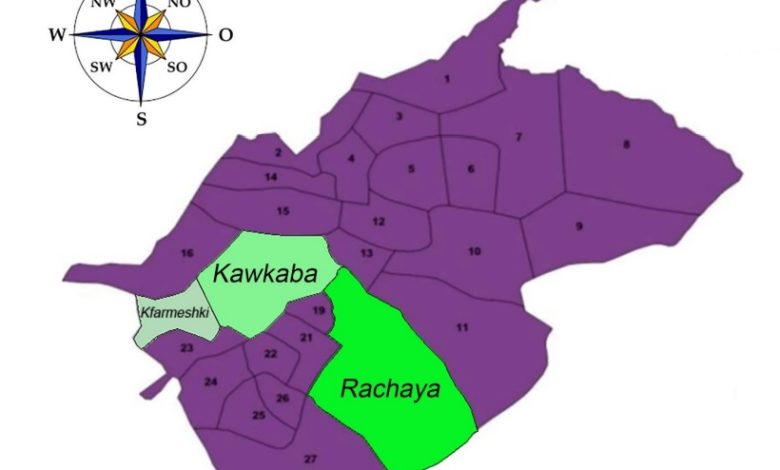
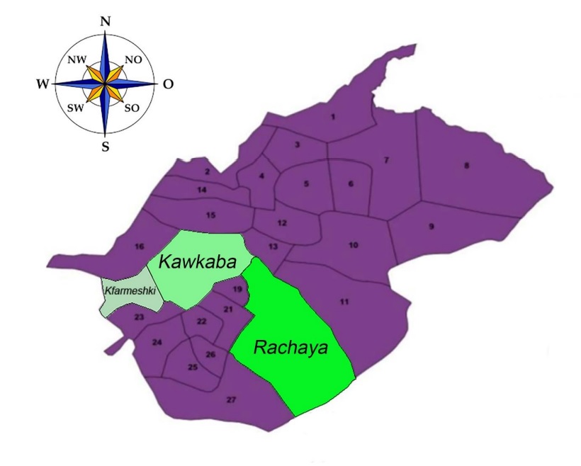
In order for the project to be more diversified in test and results, Three sites were chosen within Mount Hermon KBA due to their differences in types of plantation (traditional, intensified), age of the olive trees, altitudes, soil specification and socio-economic infrastructure. The three sites are:
– Site 1: Rashaya
– Site 2: Kawkaba
– Site 3: Kfarmishki
The project aim in these sites is to safeguard the traditional management practices in the olive sector and ultimately biodiversity conservation.
Site 1: Rashaya, 33.5119336, 35.8401382
Rachaya, Rashaiya, Rashayya or Rachaiya (Arabic: راشيا), also known as Rashaya al-Wadi or Rachaya el-Wadi (and variations), is a town of the Rashaya District in the south of the Beqaa Governorate of Lebanon. It is situated at around 1,350 metres (4,430 ft) above sea level on the western slopes of Mount Hermon (Mount Hermon is identified as an KBA for CEPF phase 2 Project).
It is still considered to be a traditional Lebanese town with its old cobbled streets and small shops, It retains a distinguished character of traditional stone houses with red tiled roofs. 1 The nearby Faqaa forest is classified as a protected area and Pine nuts from the local conifer trees are used in traditional cooking.
The Rashaya Citadel, also known as the Citadel of Independence since 1943, has been declared a national monument, having been first built as a palace in the 18th century.
The climate of the Area is Mediterranean, with 7 to 8 dry months and relatively wet winters of 4-5 months’ duration. In winter months, the area might face freezing conditions for some days. Rashaya receives between 650 millimetres (26 in) and 750 millimetres (30 in) of rainfall each year with around two fifths of this amount falling between November and March. It has an average annual temperature of 15 °C (59 °F), varying between 35 °C (95 °F) in the summer season down to −5 °C (23 °F) in winter. The dominant wind direction is east to west from which the town is somewhat sheltered by the mountains 2 .
The economy of the town is primarily based on agriculture, the services and tourism industries. Rashaya was designated one of nine poverty areas within Lebanon in a survey of 2002.
Rashaya surrounding area, has a moderate biodiversity. Beside Olives, commonly grown crops include oaks, cherries, Hawthorn (Zaarour), Sumac, Bellan and annual plants are present such as apricots and grapes. Some wild cucumbers are also grown, however vegetables are less frequently grown due to low rainfall. Animal husbandry is also practiced, mainly with
goats, of which the Labneh variety is a popular staple food for locals. Tree species such as oak, wild pistachio and sumac grow in the area. A variety of jackals, chacals and foxes, snakes, lizards and rodents can be easily found living in Rashaya surrounding area along with various species of migratory birds. Households of the town get their fresh water supply from 2 artesian
wells drilled near the town. They also get intermittent water supply from the public water supply of Chamsine source.
The main river of the area, the Hasbani River, runs some 32 km South from the city.
Site 2: Kawkaba 3 – 33.5269784, 35.78408
The name Kawkaba is of Semitic origin, and calls to mind the planets, particularly Venus the Morning Star. Kawkaba is in the region of Rashaya, a little over sixty-five miles from Beirut and 4000 feet above sea level.
Kawkaba is a village facing Mount Hermon. It receives the first rays of the sun rising over Mount Hermon and it is unique in many ways, different from others, quite apart from its picturesque aspect and the surrounding panorama. It is a marvelous place, with thousand-year-old olive trees, fruit trees and vines, and its olive groves received both Jesus and John the
Baptist. There are remains from twelve thousand years ago and from the Phoenicians and Canaanites later. There are babbling springs and streams that ensure harvests of vegetables and fruit, and historical riches to be added to those of agriculture.
Kawkaba is certainly a town much privileged, one among the most ancient towns of the Hermon region. To its east is the river Hasbani, an affluent of the Jordan River.
Site 3: Kfarmishki 4 – 33.5109496, 35.7441044
Kfarmeshki, being a splendid viewpoint with its view of Hermon, the Sacred Mountain of Lebanon, lies in the circumscription of Rashaya in the southern part of the fertile Beqaa valley, a rich plain stretching between two chains of mountains. Kfarmeshki stands at a height of nearly 4,500 feet and is just over fifty miles from the Lebanese capital Beirut.
The land covered by the village is not just one level stretch but rather a collection of plateaus, hillocks, crests and hollows, so there is a variety of views and the earth is rich and bathed by the sun. Cereal crops are grown and there are orchards with fruit trees of many kinds, particularly
cherry trees. There are olive groves and the soil particularly favors excellent viniculture. Clumps of woodland trees abound.
The local people are hard-working small farmers who cultivate their land as a labor. One has only to glance at the olive orchards and vineyards to see with what skill, care and attention they devote themselves in order to maintain fertility and have good harvests. It is no surprise to come across ruins here dating back to the times of the Romans, for they naturally settled wherever the land was productive.